Yesterday, a video was published online by the website Al-hadath News showing the type of munition used in the August 21st Sarin attack being launched from Qadam Railway Station
There's two minor points to note about this video, and one major point. At the start of the video, the cameraman describes the weapon as a "Volcano rocket". As I noted earlier this week, the "Volcano rocket" is a named used for both this weapon, and smaller IRAM-type weapons used by government forces. It seems now, we finally have a name for this weapon.
The other minor point is about the flag on the truck. It's not a great shot of the flag, but some people have noted the white circle on a black background looks a lot like the flag used by various Jihadist groups in Syria. As this photograph of the National Defence Force shows, it's not just Jihadists who use that particular colour scheme
![]()
Those are both minor points, but what's extremely unique and important about this video is it shows the impact of the rocket followed by the sound of the explosion. The detonation is at around 17.5s, and the noise of the explosion can be heard around 23.5s, so that's a delay of around 6 seconds. The speed of sound at around the altitude is around 337 m/s, so that would mean the range of the munition is around 2022 meters.
I showed this video to Richard Lloyd, who has been studying the munitions used in the August 21st Sarin attack closely, and based on the available evidence, he concluded that the munition was launched at around a 21 degree angle, with a range of around 2.1km. That reminded me of another video showing the launch and impact of a Volcano, this time fired from Mezzeh airbase
While the impact isn't visible, it appears the flight time is around 20-22 seconds, several seconds longer than the other video. Richard Lloyd believes that the longer flight time would point to a higher angle of launch, and a longer range. Based off the two videos Richard Lloyd believes a range of 2-2.5km is reasonable for the Volcano rocket. That's not to say the maximum range is definitely 2.5km, just that based of available evidence that's a reasonable estimation.
Thank to the UN report we have an idea of the direction the rockets came from, and a recent Al Jazeera Arabic documentary about the August 21st attack might even provide more information
In the film they present what they claim is more evidence from the attack, including two previously unseen Volcano rockets (bringing the total recorded to 8), and what they claim is the azimuths for those two rockets
![]()
With the UN report, that's three azimuths, 285, 290, and 307 degrees. We also know the exact impact location of two of the Volcanoes used in the attack (details here and here). Given that information, I've put together a map that shows the possible area of origin for the attack based of the possible ranges (click to expand)
![]()
What's interesting about this range and the azimuth, is it puts the possibly launch locations inside an area that was part of the Syrian Army's "Operation Qaboun", which was heavily covered by ANNA News. Their first video was posted on June 24th, with the last video posted on August 20th. It covered the attempts by the Syrian army to fight their way through a district between Qaboun and Jobar, which would act as a staging point for attacks later on in the year. Videos posted by ANNA News establish that the Syrian military were operating, and based, inside that area, for example this video from August 5th showing at the bus station to the east of the area
At 1:54 in the below video, filmed on August 10th, you can see the mosque just west of the tank base in the area
Open Source IMINT took a very detailed look at videos posted by ANNA News showing fighting in the area from September onwards, and it shows that region now being used to launch attacks both to the north and the south
![]()
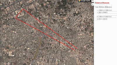
After the August 21st attack Storyful collected data on various claims about the impact locations of rockets used in the attack, including the claims by the local LCCs about the impact locations of each rocket. All the positions were plotted onto a map, with the impact locations reported by the LCC marked in light blue. According to that map, all the impact locations are within 2.5km of the area controlled by the Syrian army.
So from all this information we can conclude that the Syrian military would have been capable of launching the August 21st Sarin attack, despite the short range of the Volcano rockets.
You can contact the author on Twitter @brown_moses or by email at brownmoses@gmail.com
There's two minor points to note about this video, and one major point. At the start of the video, the cameraman describes the weapon as a "Volcano rocket". As I noted earlier this week, the "Volcano rocket" is a named used for both this weapon, and smaller IRAM-type weapons used by government forces. It seems now, we finally have a name for this weapon.
The other minor point is about the flag on the truck. It's not a great shot of the flag, but some people have noted the white circle on a black background looks a lot like the flag used by various Jihadist groups in Syria. As this photograph of the National Defence Force shows, it's not just Jihadists who use that particular colour scheme

Those are both minor points, but what's extremely unique and important about this video is it shows the impact of the rocket followed by the sound of the explosion. The detonation is at around 17.5s, and the noise of the explosion can be heard around 23.5s, so that's a delay of around 6 seconds. The speed of sound at around the altitude is around 337 m/s, so that would mean the range of the munition is around 2022 meters.
I showed this video to Richard Lloyd, who has been studying the munitions used in the August 21st Sarin attack closely, and based on the available evidence, he concluded that the munition was launched at around a 21 degree angle, with a range of around 2.1km. That reminded me of another video showing the launch and impact of a Volcano, this time fired from Mezzeh airbase
While the impact isn't visible, it appears the flight time is around 20-22 seconds, several seconds longer than the other video. Richard Lloyd believes that the longer flight time would point to a higher angle of launch, and a longer range. Based off the two videos Richard Lloyd believes a range of 2-2.5km is reasonable for the Volcano rocket. That's not to say the maximum range is definitely 2.5km, just that based of available evidence that's a reasonable estimation.
Thank to the UN report we have an idea of the direction the rockets came from, and a recent Al Jazeera Arabic documentary about the August 21st attack might even provide more information
In the film they present what they claim is more evidence from the attack, including two previously unseen Volcano rockets (bringing the total recorded to 8), and what they claim is the azimuths for those two rockets

With the UN report, that's three azimuths, 285, 290, and 307 degrees. We also know the exact impact location of two of the Volcanoes used in the attack (details here and here). Given that information, I've put together a map that shows the possible area of origin for the attack based of the possible ranges (click to expand)
What's interesting about this range and the azimuth, is it puts the possibly launch locations inside an area that was part of the Syrian Army's "Operation Qaboun", which was heavily covered by ANNA News. Their first video was posted on June 24th, with the last video posted on August 20th. It covered the attempts by the Syrian army to fight their way through a district between Qaboun and Jobar, which would act as a staging point for attacks later on in the year. Videos posted by ANNA News establish that the Syrian military were operating, and based, inside that area, for example this video from August 5th showing at the bus station to the east of the area
At 1:54 in the below video, filmed on August 10th, you can see the mosque just west of the tank base in the area
Open Source IMINT took a very detailed look at videos posted by ANNA News showing fighting in the area from September onwards, and it shows that region now being used to launch attacks both to the north and the south

After the August 21st attack Storyful collected data on various claims about the impact locations of rockets used in the attack, including the claims by the local LCCs about the impact locations of each rocket. All the positions were plotted onto a map, with the impact locations reported by the LCC marked in light blue. According to that map, all the impact locations are within 2.5km of the area controlled by the Syrian army.
So from all this information we can conclude that the Syrian military would have been capable of launching the August 21st Sarin attack, despite the short range of the Volcano rockets.
You can contact the author on Twitter @brown_moses or by email at brownmoses@gmail.com